Duration
Four lots, and how long their records run.
327 Concord Avenue, demolished 2023
What was here
A row house stood at 327 Concord Avenue.1 Walter Nash had lived there since 19642,3 the Mott Haven Herald reported in August 2023;4 by then he had boarded it up and moved in with his older brother in Harlem “to escape the hazards of living at home.” “It’s weird,” he told the paper. “They are going to build the new Rikers Island in the old Lincoln hospital.” The City said the house had “a long history of structural issues and a vacate order because the rear of the building is collapsing.”5
Under the manufacturing zoning mapped in 1961, a home on this lot may be rebuilt only for a use the district permits. Existing homes in manufacturing zones may be repaired,6 but structural alteration is barred, with narrow exceptions. Homes may be extended only on the ground floor.
The emergency declaration, March 2023
The building was demolished under an emergency declaration. The Department of Buildings issued emergency declaration EGNCY 17526 on 29 March 2023; the Department of Housing Preservation and Development executed it. The demolition job was filed on 27 June 2023, approved on 3 July, its permit issued on 21 August, and it was signed off on 27 November 2023.78
An emergency declaration is an instrument with a particular shape. It does not proceed through the review a demolition otherwise requires; it is issued by one agency and carried out by another; and it is, by its own terms, a response to a condition rather than a decision about a building’s future.
When a building is found unsafe, demolition by the City would ordinarily require a court precept first — a judicial step, on the record, with a docket. An emergency declaration removes that requirement.
What the demolition record counts
The filing describes a three-family residential building. It does not describe the families. Nothing in the demolition record — the declaration, the job, the permit, the sign-off — identifies how many people lived in the building, where they went, or whether anything was owed to them. The instrument that removed the building leaves no trace of the households it contained.
That absence is not an oversight in the paperwork. It is what the paperwork is for. A demolition record records a demolition, and a building is the thing it is about. The people in it are not a category the form has.
The ownership record is stranger. ACRIS, the city’s register of recorded documents, holds no document of any kind for this lot — not in its real property records, not in its personal property records, across every document type its published data carries. The three neighboring lots on the same block hold seventeen, thirty-nine and eleven documents between them.9
A lot with no recorded ownership history, beside lots with decades of it, is not a lot that was never owned. It is a lot whose ownership has no document in the City’s digital register.
The lot today
The lot has been vacant land since.
What the records show
A building the City’s own filings describe as three-family housing was made the subject of an emergency declaration by one agency, taken down under the direction of another, and signed off eight months later. Every step produced a record, and each record is exact about the building: its number of stories, its class, its job number, its permit. None of them records who lived there, where they went, or whether anything was owed to them.
The local press did. In August 2023, the Mott Haven Herald reported Walter Nash’s account that construction on the jail site had damaged the house, and that it was boarded up that spring.10 The Department of Design and Construction, which is building the jail, contested his account and its timeline, citing the house’s condition before construction began and an earlier vacate order.1112 In the challenge to the jail’s siting, Nash was named among the residents living across from the tow pound.
That gap is the finding. A local newspaper could name a man it reported living there, and print the City’s dispute of his account. The instruments that removed the building carry no category for him. What remains is a vacant lot, its land now assessed well above the land next door, where a house still stands, and a demolition job that was opened and closed.
745 East 141st Street and 320 Concord Avenue, 1898–2026
Before the tow pound
Wales Avenue used to run through it. The street was eliminated, discontinued and closed by a city map change — the maps dated 17 November 1942, the City Planning Commission on 24 February 1943, the Board of Estimate on 11 May 1944 — to consolidate the street with the hospital site. Two blocks became one.15
That is the first instrument this block’s record carries, and it is the same instrument as the last. A map change in the 1940s took a street off the map so a hospital could occupy both sides of it. A map change in 2019 rezoned a hundred-foot strip of the same block’s Concord Avenue frontage for housing beside a jail. Seventy-five years, one block, the same kind of action.16
What this ground was
The report that selected the Bronx site describes a City-owned block bounded by East 142nd Street, Southern Boulevard, Bruckner Boulevard, East 141st Street and Concord Avenue. The jail site sits on the eastern portion of that block.
The lot the Bronx facility stands on is Block 2574, Lot 1, with a lot area of 145,635 square feet.
This ground is often described as the former Lincoln Hospital, and the selection report mentions it once: in the Bronx Borough President’s recommendation, which describes the site as a brownfield because rubble and hazardous material from the former Lincoln Hospital site were dumped here before it was converted into a tow pound.21 That is the Borough President’s statement and is reported as his. It describes a building demolished in place, not debris brought from somewhere else.22
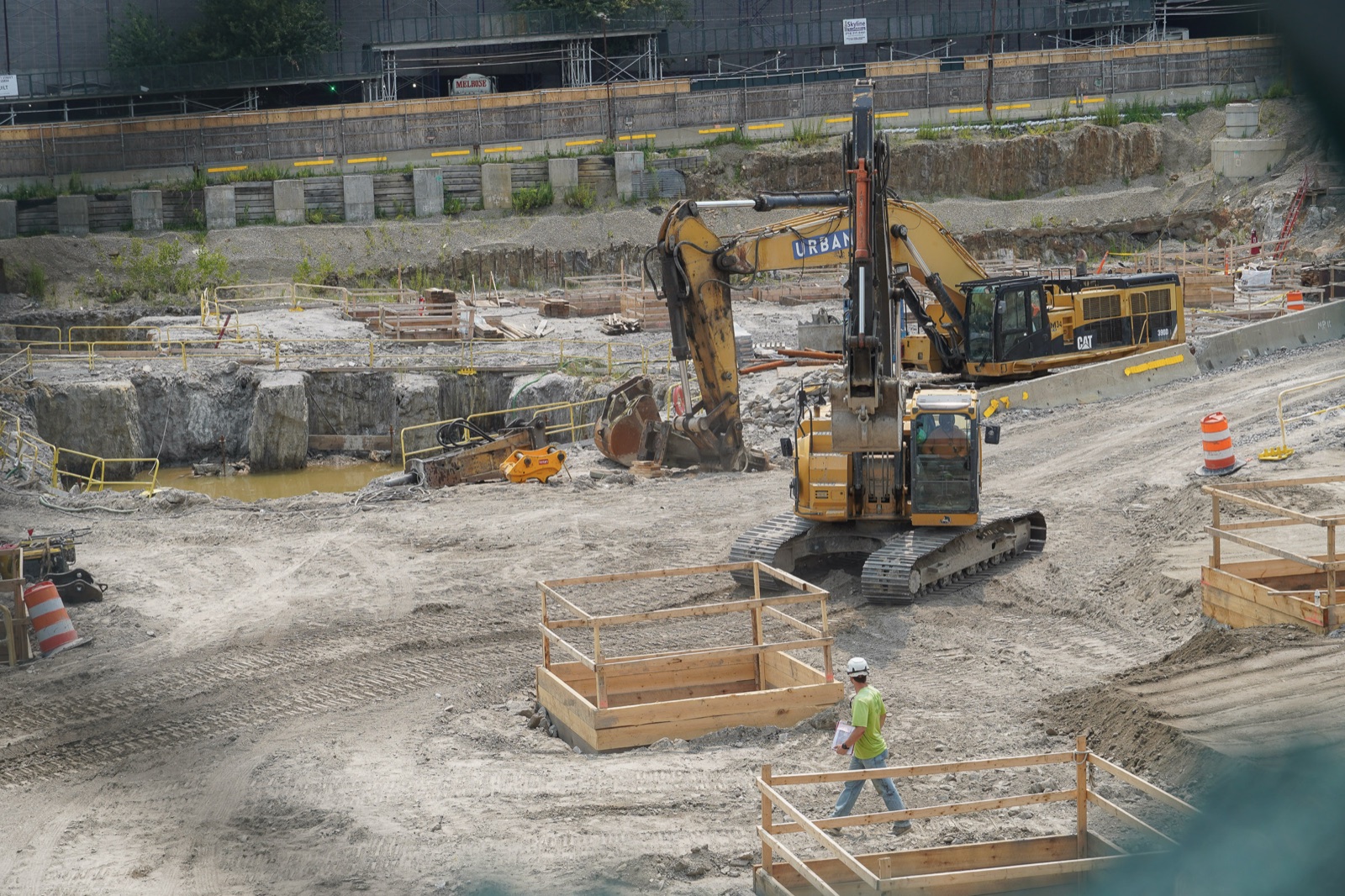
Five stationary meters on the site’s perimeter recorded hourly noise from January to July 2026. Their median hourly levels ranged from 67.1 to 77.2 dBA.23 Vibration is modeled from the Federal Transit Administration’s reference level for construction equipment.
One lot, two addresses
In 2019 five applications acted on this single piece of ground, and the three that named it by address did not call it the same thing. The site selection names 745 East 141st Street. The special permit for the jail names 320 Concord Avenue. The housing action names both addresses together. All three describe part of Lot 1 of Block 2574. The other two name no address at all: one rezones the western portion of the block, the other adds an area to the Zoning Resolution’s inclusionary housing appendix.24
The disagreement did not end in 2019. Today the City’s address directory gives 320 Concord Avenue to Lot 1 and 745 East 141st Street to Lot 2, and the inventory of municipally owned property gives Lot 1 the same address, with the description future jail. MapPLUTO, the City Planning extract that joins tax-lot shapes to assessment records, prints the two the other way round, and contradicts itself in doing so: the point the address directory returns for 320 Concord Avenue falls inside the shape MapPLUTO itself draws for Lot 1. The lots are where all three records say they are. One record’s text is wrong about which is which.25
This is a small thing and it is the whole subject of this page. A parcel is not a place. It is a set of entries in registers that are maintained separately, updated on different schedules, and under no obligation to agree with one another. What can be said about a lot depends on which register you ask: in 2019 three applications named this one piece of ground three ways, and a City extract still labels its two lots the wrong way round.
The 2019 application: a jail and housing together
Six actions were filed together and decided together; five of them acted on this ground.
Read separately these are six ordinary land-use items. Read together, which is how they were filed, they are one procedure producing a jail and a quantity of affordable housing from one block in one motion. The mixed-use district is the clearest evidence: not two applications that happened to arrive together, but a single instrument creating a category of ground that admits both.
The housing strip on Concord Avenue, 2019
Three of those instruments describe the same strip. The housing site is the western portion of the block within a hundred feet of Concord Avenue. The rezoning changes the district within a hundred feet of Concord Avenue. The mixed-use district is established on that same boundary. The housing site, the map change and the new district are coextensive: one strip of ground, three instruments, the same line.26
What the zoning allows on the lot
The stepping-down matters more than the reduction. What steps down is the jail’s permitted height: 195 feet overall, 175 where the building meets the housing site and 155 at the southern end. The jail’s form was shaped, in the document, by the presence of the housing beside it. They were not designed in ignorance of one another and later discovered to be neighbors. They were drawn together.
Where the lot split is recorded
The housing action designated part of Lot 1, approved it, and authorized its disposal. It did not divide it. The division came later: the Department of Finance apportioned Block 2574 into two lots on 6 May 2024, effective for the 2024–2025 tax year. Lot 1 is the jail site; Lot 2 is the mixed-use site, on the western portion the rezoning had covered. The applications of 2019 acted on a lot that did not exist until 2024.
How these documents were found
Most of the land-use record for this site comes from exhibits filed in a lawsuit. Diego Beekman Mutual Housing Association HDFC and Walter Nash brought an Article 78 proceeding against the City and its agencies over the siting of this facility. Their counsel’s reply memorandum describes them as “longtime homeowners”, a party’s characterization reported as that.29 The petition was dismissed in March 2021. The appeal was deemed withdrawn in April 2022, on correspondence from the petitioners’ own counsel. The case did not succeed.303132
It did assemble the City’s land-use record for this site into one place and put it on a public docket: the commission reports, the technical memoranda, the community board forms, the agency letters, the advisory committee papers. The record read here was gathered as evidence by people who lost.33
Diego Beekman, 2003–2026
The Diego Beekman buildings
Diego Beekman Mutual Housing Association HDFC holds a portfolio of residential buildings in Mott Haven, including buildings on Cypress Avenue.
Private Housing Finance Law §610 permits the owner of regulated affordable housing to charge a subsidized tenant above the legal regulated rent, with the difference covered by rental assistance. Correctly applied, the tenant’s own payment does not move. The instrument is invisible to the person it governs.
Misapplied, the increase passes to the tenant. Nobody has to decide to raise anyone’s rent. The mechanism does it, and the first party to learn of it is the household whose payment changed.
Guidance clarifying the correct application was issued in December 2024. A proceeding filed in April 2025 alleges the misapplication continued after it.34
Keeanga-Yamahtta Taylor’s term for a benefit whose risk is transferred to the person it includes is predatory inclusion. Her case is federal homeownership policy; the mechanism here is a rent formula. What is shared is the direction of travel: the cost of the instrument’s failure lands on the household the instrument was built to assist.
Sixteen vacate orders on ten lots
Between March 2014 and October 2025 the City’s housing department issued sixteen vacate orders on ten of the association’s tax lots; nine record no rescission. Across the district, two in five of the City’s vacate orders record no rescission. The only order covering an entire building is at 345 Cypress Avenue, effective 29 April 2025: 41 units, with no rescission recorded. At 354–370 Cypress Avenue — one tax lot carrying five buildings — two partial orders are recorded, rescinded in May 2021 and December 2025.35
No rescission recorded is not the same as still vacated. The record shows when an order was lifted, and for 345 it shows no date.
The preservation project opened in 2018
An HPD preservation project, number 65227, named for the association, began on 26 June 2018. It records unit commitments and, as of August 12, 2026, no completion date.36
What is withheld
Some of what this project holds about the portfolio is not published. About, “Two kinds of gap: silence in the record, and withholding” sets out what is withheld and why.
What the records show
This is housing that is already affordable, held by a mutual housing association under a City preservation program. The instruments here are not a jail’s, but they have the same shape: an order with no recorded end, a project with commitments and no completion date. Affordability does not take a building out of managed time.
349 East 140th Street, 2013–2026
What the building was
The building at 349 East 140th Street was the Lincoln Hospital Recovery Center, a City health facility.37
When it closed
No City register dates its closing.38 The City’s property file still lists its use, as of 29 April 2026, as an ambulatory health facility held by Health + Hospitals. The City’s facilities database still lists an alcoholism outpatient clinic there, operated by Health + Hospitals, from State health department data.39
A site review filed in October 2020 in the litigation over the jail’s siting gives its current use as vacant.40
At a public hearing Health + Hospitals held on 10 July 2025, the proposed lessee’s presentation, which Health + Hospitals published, said the building closed and was vacated in 2013.41
Four records, three states, one building.
How it is being reopened
In October 2022 the City’s Economic Development Corporation published a solicitation for the site’s long-term sublease and redevelopment, with responses due in January 2023.42
The proposed lessee’s presentation says it was selected as conditional developer in 2023.43
Health + Hospitals held a public hearing on a proposed lease on 10 July 2025. Financing and lease documents dated 30 July 2026 were recorded on 12 August. The parties to those documents include the Mott Haven–Port Morris Community Land Stewards and The Reinvestment Fund.44
What the records show
This is the counter-case. A community-led project to reopen a City health building is moving through the same apparatus as the jail, 3,915 to 4,176 feet (0.74 to 0.79 miles) away, measured centroid to centroid: a solicitation, a designation its presenters report, a public hearing on a proposed lease, recorded financing. What differs is time.
The building it seeks to reopen has no agreed state in the records: two City registers still list a clinic there, a 2020 court filing gives its use as vacant, and the proposed lessee’s presentation, published by the agency that holds it, says it closed in 2013.45
Sources
Case study one: 327 Concord Avenue
- Department of Buildings, DOB NOW: Build — Job Application Filings (w9ak-ipjd) and Approved Permits (rbx6-tga4), BIN 2003857, job X00872419, as of September 11, 2026
- Department of Housing Preservation and Development, Open Market Order Charges (mdbu-nrqn) and HPD Online, work order DN00439
- Department of Finance, ACRIS Real Property and Personal Property Legals (8h5j-fqxa, uqqa-hym2), as of September 18, 2026
- Department of City Planning, MapPLUTO 26v2, building class and AssessLand
- Department of Finance, ACRIS Real Property Legals (NYC Open Data), as of September 18, 2026
- Department of City Planning, MapPLUTO 26v2
- Index 260402/2019E, Doc 210, Amended Verified Petition, p. 41, filed August 31, 2020
- Index 260402/2019E, the documents filed, as of September 2026 · MapPLUTO 26v2 · Department of Finance, assessment roll; and ACRIS, as of September 2026 · property registrations, as of September 2026 · Department of Buildings, DOB NOW and the Buildings Information System, as of September 2026
Case study two: 745 East 141st Street / 320 Concord Avenue
- Sanborn Map Company, Insurance Maps of the City of New York, Borough of the Bronx, vol. 9, plate 53. New York Public Library, image 1990853, 1908
- Supreme Court of the State of New York, Bronx County, Index 260402/2019E, Doc 22, Bronx Land Use Review Application, p. 13
- Department of City Planning, Zoning Application Portal, ULURP C820154PPX · City Planning Commission, C 190333 PSY, p. 9, September 3, 2019 · Department of City Planning, City Owned and Leased Property (COLP), April 29, 2026 · Department of City Planning, MapPLUTO 26v2, Address field
- Bronx Land Use Review Application (NYSCEF Doc 22, Index 260402/2019E), p. 13, filed June 11, 2020
- Tamiment Library and Robert F. Wagner Labor Archives, New York University, Daily Worker and Daily World Negatives Collection, Series II, folder “Young Lords Sit-In, Lincoln Hospital, Bronx, New York”, July 14, 1970
- Sanborn Map Company, Insurance Maps of the City of New York, Borough of the Bronx, vol. 9, plate 53. New York Public Library, image 1990853, 1908 · Index 260402/2019E, Doc 22, Bronx Land Use Review Application, p. 13, filed June 11, 2020
- “Map Closing and Discontinuing Wales Avenue between E. 141st St. and E. 142nd St.”, Plan No. 11170, November 17, 1942 · land use report, NYSCEF Doc 22, Index 260402/2019E, p. 13
Case study three: Diego Beekman
- Department of City Planning, MapPLUTO 26v2, owner name field · Department of Finance, ACRIS, deed, Secretary of Housing and Urban Development to the association, recorded July 18, 2003 · Department of Housing Preservation and Development, Order to Repair / Vacate Orders, NYC Open Data tb8q-a3ar, as of September 20, 2026 · Department of Housing Preservation and Development, Affordable Housing Production by Building, Project ID 65227, as of August 12, 2026
- MapPLUTO 26v2, owner name on Bronx block 2571 lot 14 (354–370 Cypress Avenue), block 2554 lot 49 (345 Cypress Avenue), and 36 further Bronx lots, August 2026 · Department of Finance, Office of the City Register, ACRIS: deed from the Secretary of Housing and Urban Development to Diego Beekman Mutual Housing Association, dated February 12, 2003, recorded July 18, 2003
- Order to Repair/Vacate Orders (NYC Open Data, tb8q-a3ar), the association’s 37 tax lots, as of October 27, 2026 · MapPLUTO 26v2 — the 37 Bronx tax lots recorded in Diego Beekman entity ownership, and the lots of Bronx Community District 1 (CD == 201), version 26v2
- Department of Housing Preservation and Development, Housing Litigations (NYC Open Data), as of August 29, 2026 · Author’s analysis of Department of Housing Preservation and Development, Housing Litigations, case types sorted by whether an agency or a tenant brings them
- Keeanga-Yamahtta Taylor, Race for Profit: How Banks and the Real Estate Industry Undermined Black Homeownership (University of North Carolina Press, 2019)
Case study four: the HEArts Center
- Department of City Planning, City Owned and Leased Property (COLP), release of April 29, 2026 · Department of City Planning, NYC Facilities Database, release 26v1 · The City Record, solicitation PIN 10066, October 6, 2022 · Supreme Court of the State of New York, Bronx County, Index 260402/2019E, Doc 223, “Rikers Closure Site Review”, p. 9, filed October 29, 2020 · Department of Finance, ACRIS parcel index, Bronx block 2303 lot 58, recorded August 12, 2026 · Department of City Planning, MapPLUTO 26v2 lot polygons, EPSG 2263
- The City Record, NYC Economic Development Corporation, solicitation PIN 10066, “H+H Lincoln Recovery Center Site”, October 6, 2022 · “Rikers Closure Site Review,” site profile of the former Lincoln Hospital Recovery Center (NYSCEF Doc 223, Index 260402/2019E), p. 9, filed October 29, 2020 · MapPLUTO 26v2, Bronx block 2303 lot 58: owner NYC Health and Hospitals Corporation, building class I5, built 1936
Cited throughout
- Bronx Borough President
- City Planning Commission
- Department of City Planning
- Department of Housing Preservation and Development
- Mott Haven Herald
- NYC Health + Hospitals
- Supreme Court of the State of New York, Bronx County
See THE GAP.